
Grid reference systems: What are they?
This page explains grid reference systems, with specific emphasis on New Zealand. If you are interested in making a grid reference system for your map read this page and then see:
What is a grid reference system?
A grid reference system is a simplified grid used for a map area to make reporting and looking up coordinates easier.
In a grid reference system each grid line on the x axis and y axis is labelled sequentially with a two-digit number(much like a graph). Gridlines may be 10,000, 1000, 100m apart. We estimate or measure the position of the points between two grid lines. As with most coordinate systems we report Easting followed by Northing.
In the example below the “T” is at 042 066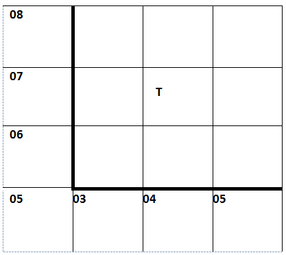
In a grid reference system the number of significant figures indicates the precision of positions. So we could also report “T” as 0424 0662 if we measured it more precisely.
Grid reference systems are good for:
- reducing the number of digits needed to identify a position on a map
- representing the precision of a measurement
- making it easier to look up and report positions
They are bad because they:
- obfuscate the underlying coordinate system
- need to be converted to full grid reference coordinates to use in GIS
How do grid reference systems relate to coordinate systems?
Grid reference systems are usually a simplification of an underlying projected coordinate system.
Projected coordinate systems
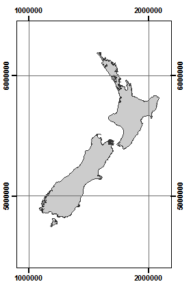
A projected coordinate system will typically cover a certain useable area. For example New Zealand Transverse Mercator Projection (NZTM) covers the entire New Zealand mainland. A projected coordinate system has a scale in metres. For every location within the useable area, there is a pair of coordinates: the distance in metres East and North of the origin.
For example in NZTM:
- Dunedin is at ~ 1,408,000m 4,920,000m
- Auckland is at ~ 1,747,000m 5,943,000m (further north and east of Dunedin)
If we were to make a map covering a small area in New Zealand we can still use NZTM coordinates to uniquely identify the positions. Below in the map of the Otago Harbour, Dunedin, point A is at
1415326 m E 4923717 m N
TIP: NZTM is designed so that the Easting is always smaller than the Northing.

Reporting coordinates with full eastings and northings is a bit tedious and takes up a lot of space in the text.
The grid reference system simplification
The interval for the grid lines on the map above is 1000m, only the thousands and ten thousands number is changing in the x-axis. For each gridline we can get rid of the first two numbers. We can also remove the trailing zeros. See the map below.
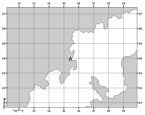
Now when we report the Location of “A” we can write 155 238. Which gives us the position to the nearest 100m.
Grid reference systems used with paper map series in New Zealand
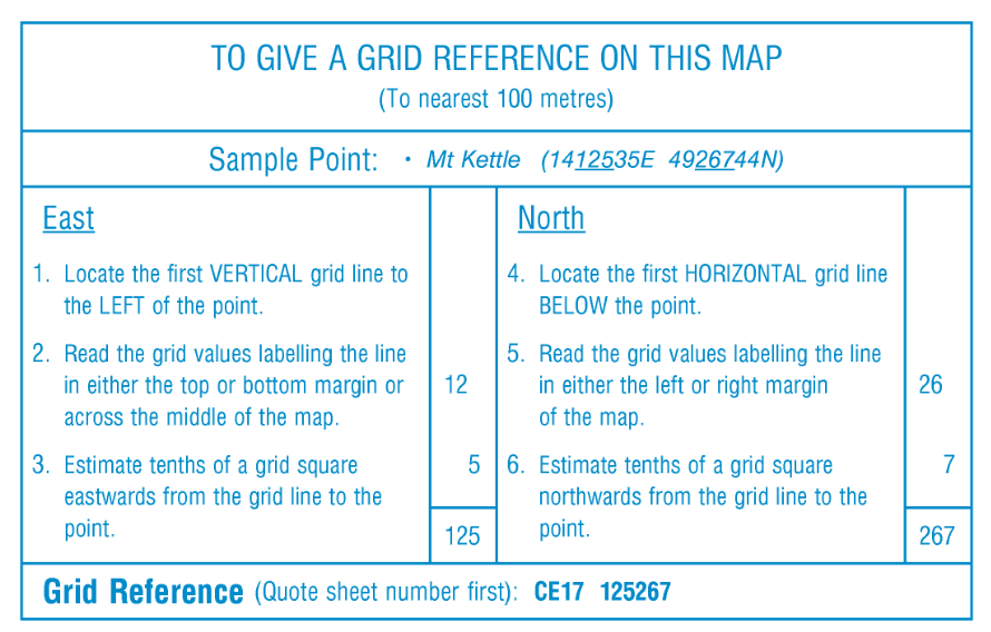
Grid reference systems covering NZ have been used in conjunction with paper based map series. In the current topo50 map series each map sheet has a unique ID such as CE17. When referring to a position we write the map sheet followed by the grid reference. So “A” in the example map above is:
CE17 155 238
Anyone wanting to find this position would first get the CE17 map sheet and then locate 155 238 on that map sheet. Below are the instructions provided on the actual CE17 topo50 map.
It is much more convenient when dealing with localities not on a specific map you provide to give the full eastings and northings so they can be inputted directly into a GIS.
Older grid reference systems used in New Zealand
There are older map series used in New Zealand
- NZMS260 –map sheets identified with one letter followed by numbers e.g. R27
- NZMS1 – map sheets identified with either S for South Island or N for North Island followed by up to 3 numbers e.g. S127
It may be difficult to tell them apart, unless you know the general area where the points should plot.
Use the LINZ conversion site to convert between various coordinate systems and grid reference systems.
How to make a grid reference system
If you want to make a grid reference system for any map read these instructions: