The Home folder in ArcGIS
The problem
Isn’t it annoying having to constantly navigate to this that and the next place to save, export or open files? This is especially an issue when dealing with ArcGIS where you have connections between data and maps to maintain.
The solution for ArcGIS 10.0: the Home folder
The home folder is the folder where your map is saved. So if you locate your maps as high up your folder hierarchy as possible you can navigate to all your data from there.
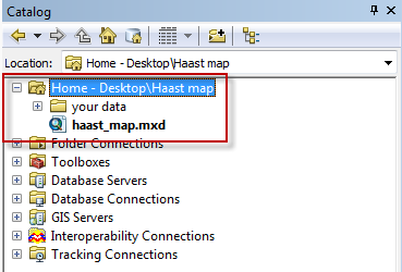
Home folder in ArcCatalog
The Home folder in ArcCatalog appears at the top of the list. Sometimes you need to scroll up to see it.
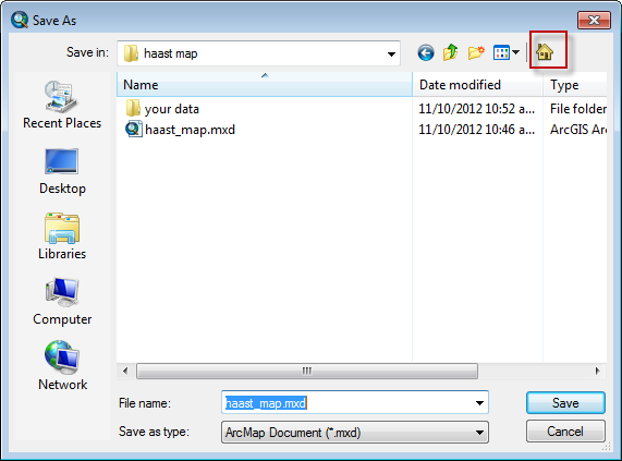
Home folder in Save or export dialog
The Home folder also appears on the save or export dialog boxes. It’s pretty subtle though (I only just noticed it!).
The home folder appears in a few other places where you open/save/export/import. Keep a look out for it to save time!
Coordinate systems in ArcGIS 10
One thing that has always frustrated me in ArcGIS is selecting coordinate systems. ArcGIS does feature a “favourites” options for coordinate systems but this only appears in a couple of dialog boxes.
The solution: Just copy and paste the coordinate system files to the same folder as all your coordinate systems.
On my computer the path was C:\Program FIles (x86)\ArcGIS\Desktop10.0\Coordinate Systems.
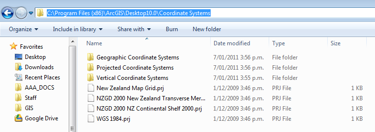
Now when I browse they appear right under coordinate systems.

Datums and Projections
A basic understanding of datums and projections and how they are used is essential for anyone conducting research with a mapping/spatial component to it.
A reasonably good summary of geodetic datums and projections is written here (read this summary first) : http://www.linz.govt.nz/geodetic/find-out/understanding-datums/index.aspx
Some Key points about datums and projections
In general
- The most important thing to know is what datum + projection the data are in
- When someone gives you data ask about what datum + projection the data are in.
- Check what the GPS is set to!
- People may tell you “The data are in Lat long” this is not a datum, it is a way of expressing the positions in a datum! Latititude and longitude could be given for any datum! (it is most likely that data will be wgs84 datum).
NZ data specifically
- If you are entering location data into a spreadsheet put the datum or projection in the header (e.g. |Easting_NZTM| Northing_NZTM| )
- When reporting eastings and northings report eastings first (like other x,y coordinates). For latitude and longitude, latitude is often reported first (not sure why this is).
- There is ~200m difference between nzgd1949 and nzgd2000 datums
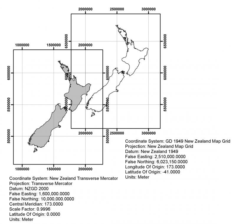
- For NZMG and NZTM the easting is always the smaller of the two (unless you are using it outside of onshore nz- which you shouldn’t).
- NZTM and NZMG Eastings/ northings are of the order of a million metres. So if you see one that that is “123456” or “12345678”, they are wrong (probably mistyped).
- NZMG eastings begin with 2 e.g. 2345346 and NZTM eastings usually begin with 1 (e.g. 1345657). There is no overlap in the coordinates for onshore New Zealand (see map below). This is by design.
For more info go to: http://www.linz.govt.nz/geodetic/datums-projections-heights