March 2019 Project Update
Recent Highlights by Professor Mark Stirling
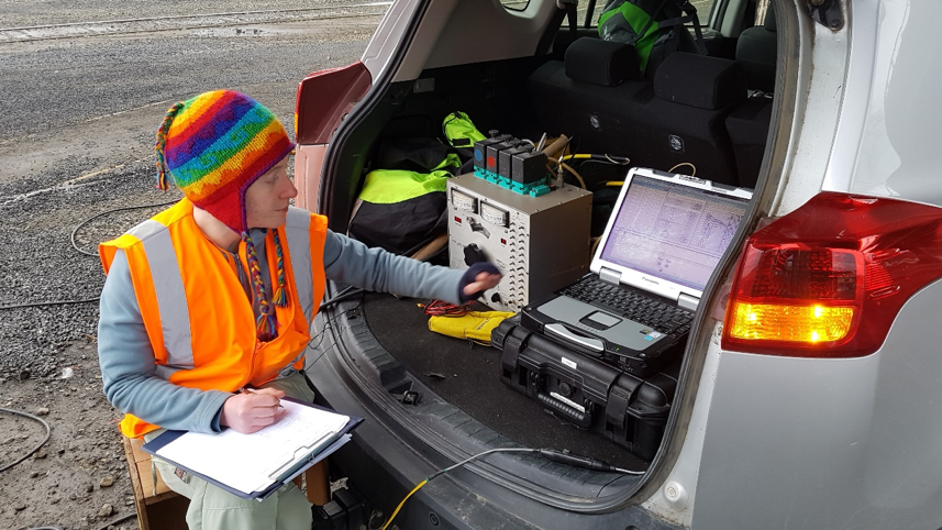
Our group has been very active over the summer field season, and I am hard-placed to remember when I last had more than two days in a row at home/office in that time. My wonderful team now numbers seven, with Dr Erin Todd as our postdoctoral scholar, and five grad students. Three are PhD (Anna Kowal, Jonathan Griffin, and Sam Allan), and two are Masters (Catherine Sangster and Ella van den Berg). We are happily undertaking work across a broad spectrum of earthquake science, including paleoseismology, physics-based seismic hazard modelling, and integrative modelling of earthquake behaviour in low-seismicity regions. I won’t say anything about the details of this work, as team members have provided material on their work on this website (see below). In general my movements have been focused on their work in New Zealand and overseas, plus other initiatives here and abroad. In short, here is the brief version of my work activities since early November:
- Natural Hazards Research Platform workshop on 2016 Kaikoura earthquake paleoseismology, Blenheim/Kaikoura, with Ella van den Berg and Sam Allan also participating. Early November.
- Japan-Taiwan-New Zealand annual seismic hazard workshop, Oamaru. Lead convener of workshop, with Erin Todd, Matt Gerstenberger and Bill Fry as co-conveners. Around 70 participants, with pre and post workshop fieldtrips to Kaikoura earthquake ruptures and central Otago, respectively. Entire earthquake science team involvement. Mid November.
- International workshop on seismic hazard, KAUST, Saudi Arabia. Invited keynote speaker. Late November.
- Travel to California for meetings with colleagues at UC Davis and PG&E to progress work on the use of fragile geologic features to constrain seismic hazard models. Early-mid December.
- Became member of University buildings advisory committee, to address issues of seismic safety of existing buildings. January.
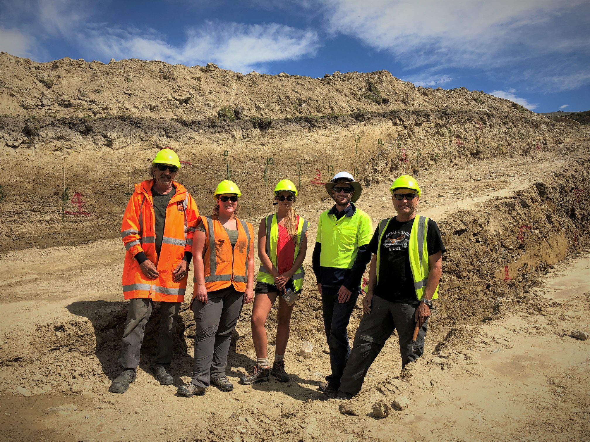
- Travel to Nepal with Sam Allan to start her PhD on determining the geometry, earthquake rupture dimensions and seismic hazard of the Himalayan Frontal Thrust. Mid January.
- Meetings at GNS Science, Avalon (my old employment place 1998-2015) to assist with hosting Taiwanese colleague visits, and in the preparation of various research proposals. January/February.
- Paleoseismic investigations of the Cardrona and Hyde Faults, central Otago (Ella van den Berg’s MSc, and Jonathan Griffin’s PhD work). February.
The financial support of EQC, Contact Energy Ltd, PG&E, and University of Otago has made the above possible, and is greatly appreciated. Now I am back in the saddle at the University to coordinate (manage) EAOS111, our largest first-year class (165 enrolled as of a week ago) and get on with my other “office based” commitments. EAOS111 is hugely important to our Geology Department, as we recruit future geologists based on their experiences in this class. The Geology Department now has a permanent full-time Teaching Fellow, Dr Sophie Briggs on board, so EAOS111 will be in even better shape this year! On a sad note, Erin’s Postdoc will finish in April as my two years of Postdoc funding will run out at that time. This means that her wonderful work on analysis of microseismicity in Otago, work streams and profile in the field of Hikurangi subduction zone slow-slip and tremor, and science education activities will have to happen in a different way. We will miss Erin greatly, but are very happy to see she has scored a job with Golder Associates in Christchurch, in part as the result of a well-timed meeting with a Golder senior at our Oamaru workshop. At least New Zealand will not lose you, and we will stay in contact in the name of collaboration and friendship!!!
Yours truly on the way home from KAUST workshop, Saudi Arabia, Nov 2018.
Postgraduate Research — March 2019
Anna Kowal
PhD funded by QuakeCoRE to undertake 3d shear wave velocity modelling for ground motion simulations in Dunedin and Mosgiel.
As large earthquakes have not been experienced in the area of interest in the historical and instrumental records, user-specified scenario simulations are of great value.
First attempts at source modelling and ground motion simulations were being carried out using the Southern California Center Broadband Platform. The platform computes 0-10 Hz seismograms for earthquakes.
Physic-based Graves and Pitarka method used explicitly incorporates source and wave propagation effects developing simulated seismograms for the site of interest. The site is defined in Dunedin CBD (railway station). Akatore and Titri faults – the closest major active faults to Dunedin are sources considered in ongoing work. Other sources (including Alpine Fault) are going to be taken into consideration in future scope of this study.
Current work and ongoing goals focus on modelling non-linear site effects. Seismic site effects are related to the amplification of seismic waves in surficial geological layers. The surface ground motion may be strongly amplified if the geological conditions are unfavourable (such as sediments). This stage aims for site response analysis via nonlinear total and effective stress 1D wave propagation for site effects in physic-based ground motion simulation and is being performed in cooperation with University of Canterbury and University of Auckland.
The next steps will move towards 3D simulations using comprehensive geological and geophysical model developed in parallel to this study (Sangster et al.)
The images below show the location of the Akatore and Titri Faults relative to Dunedin, an example of simulation results: synthetic acceleration seismograms and fault slip distribution and example of site effect on the acceleration seismogram.
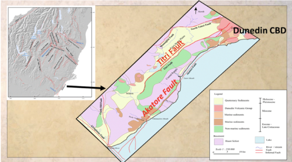
Schematic position of sources and path on the geological structure background of the area
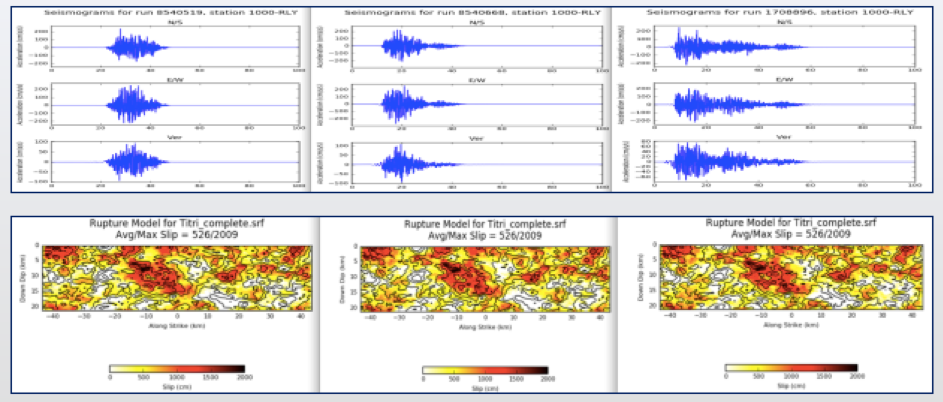
Simulations results example for Titri fault: 87 km fault length, Mw =7.7. From left to right hypocenter located in southern, central and northern part of the fault. Accelerograms (above) with corresponding slip distributions (below).
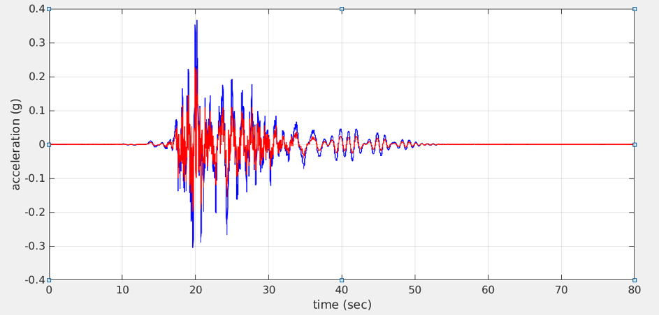
Example of site effect (blue line) with non-site effect (red line) overlaid acceleration seismograms for Akatore fault: 60 km fault length, Mw = 7.4, N-S motion direction.
QuakeCoRE is acknowledged for their support of Anna’s PhD through their PhD scholarship programme.
Catherine Sangster
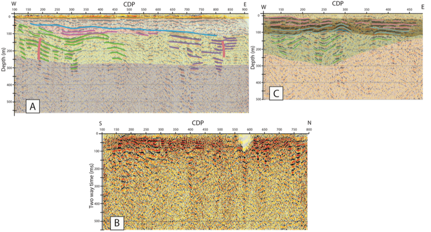
MSc funded by University of Otago and QuakeCoRE to undertake groundwork for development of a 3D shear wave velocity model for Dunedin from multiple datasets. Most significantly, Catherine has led the acquisition, processing and interpretation of three seismic reflection profiles. The three profiles are shown below, with locations shown in the map (Profile A is the pink profile, B is the yellow one, and C is the blue one). In addition to providing valuable input to the 3d model development, Profile A has also been used to eliminate the possibility that the Akatore Fault is present within 10km of Dunedin city centre. QuakeCoRE is acknowledged for their partial support of Catherine’s work.

Ella van den Berg
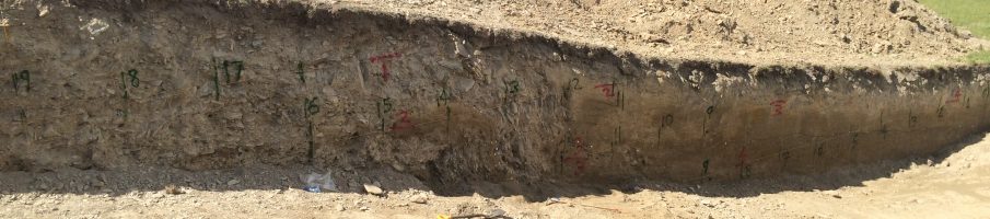
The trenching revealed a great exposure of offset alluvium units, and evidence for two earthquake events. Once dated, the samples will yield enhanced age control and constrain late Quaternary activity on the NW Cardrona Fault. The support of Contact Energy Ltd is acknowledged for Ella’s fieldwork and laboratory costs.
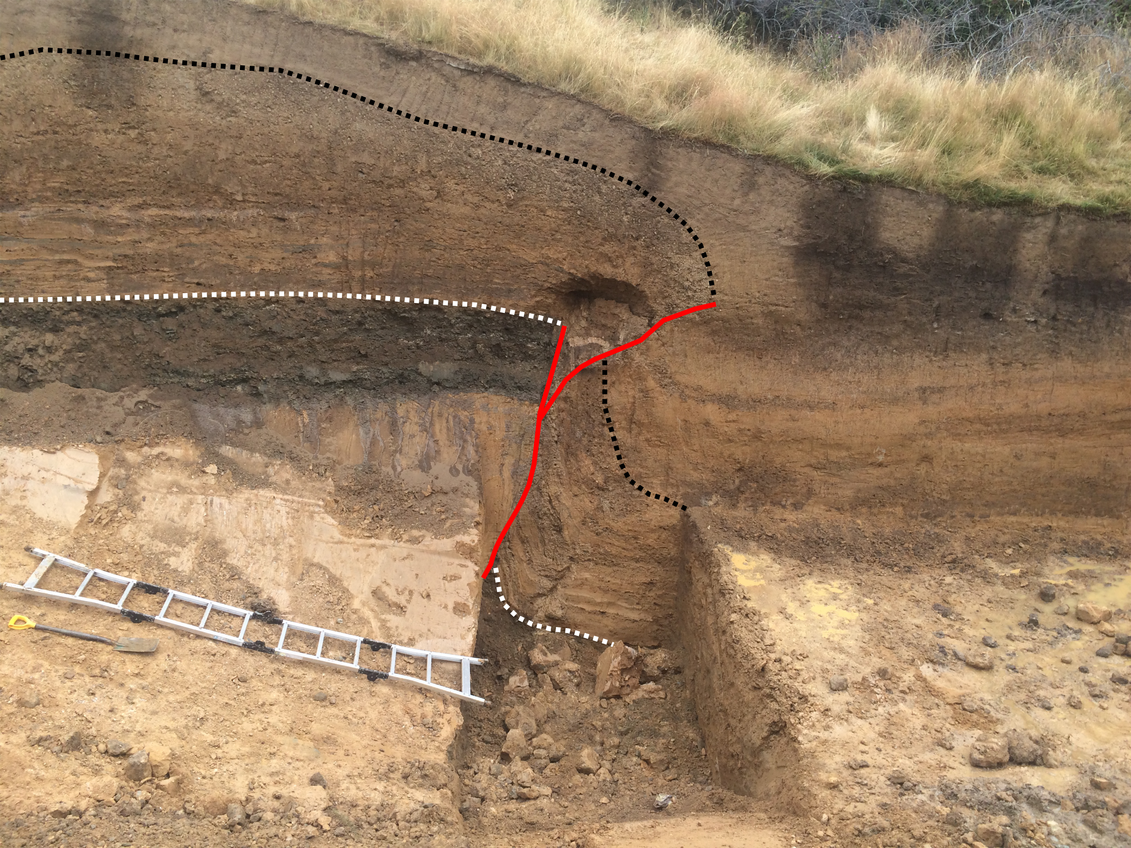
South-facing view of the trench wall showing the Cardrona Fault (red lines) and offset alluvium units. The most recent earthquake event has displaced the gravel unit (top marked by dashed black line) in the upper part of the trench.
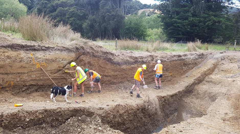
Jonathan Griffin
In February we spent a week in Middlemarch undertaking the first palaeoseismic study of the Hyde Fault, one of the three major known faults near to the city of Dunedin. The team excavated two trenches across the fault and looked at offsets in sedimentary layers to unravel the history of earthquakes on the fault. Sediment samples will be dated over the next few months to determine when past earthquakes have occurred here. The study aims to answer two main questions: How often do earthquakes occur on the Hyde Fault, and how big are they? The answers will provide important information for seismic risk mitigation in Dunedin and surrounding regions. Fieldwork was undertaken by Mark Stirling, Jonathan Griffin, Ella van den Berg, Erin Todd, and Ross Nicolls from UoO with assistance from David Barrell and Nicola Litchfield (GNS Science).
The Hyde Fault study forms a component of Jonathan Griffin’s PhD research. Supported by a Development Grant from Geoscience Australia, he is looking at earthquake occurrence on faults in low seismicity regions like Otago and Australia. His research aims to:
- Understand why large earthquakes appear to cluster in time on faults in slowly deforming regions and how ubiquitous such behaviour is;
- Explore interactions between the timing of clusters on nearby faults; and
- Develop statistical models of earthquake clustering for more accurate earthquake hazard assessment.
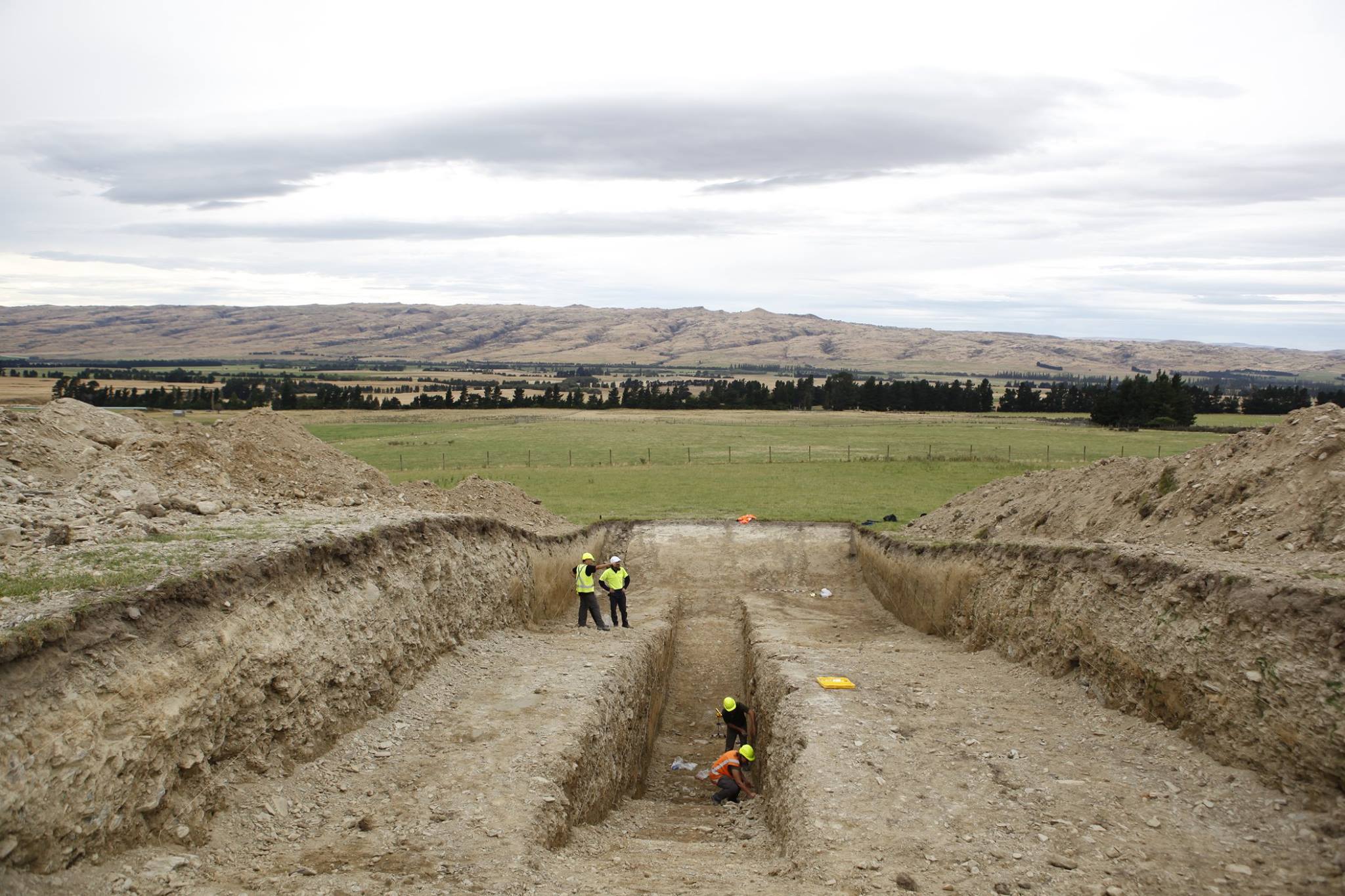
Hyde Fault trench in Middlemarch. Photo credit: Guy Frederick
The Hyde Fault trenching team. Left to right: Ross Nicolls, Erin Todd, Ella van den Berg, Jono Griffin, Mark Stirling. Photo credit: Guy Frederick
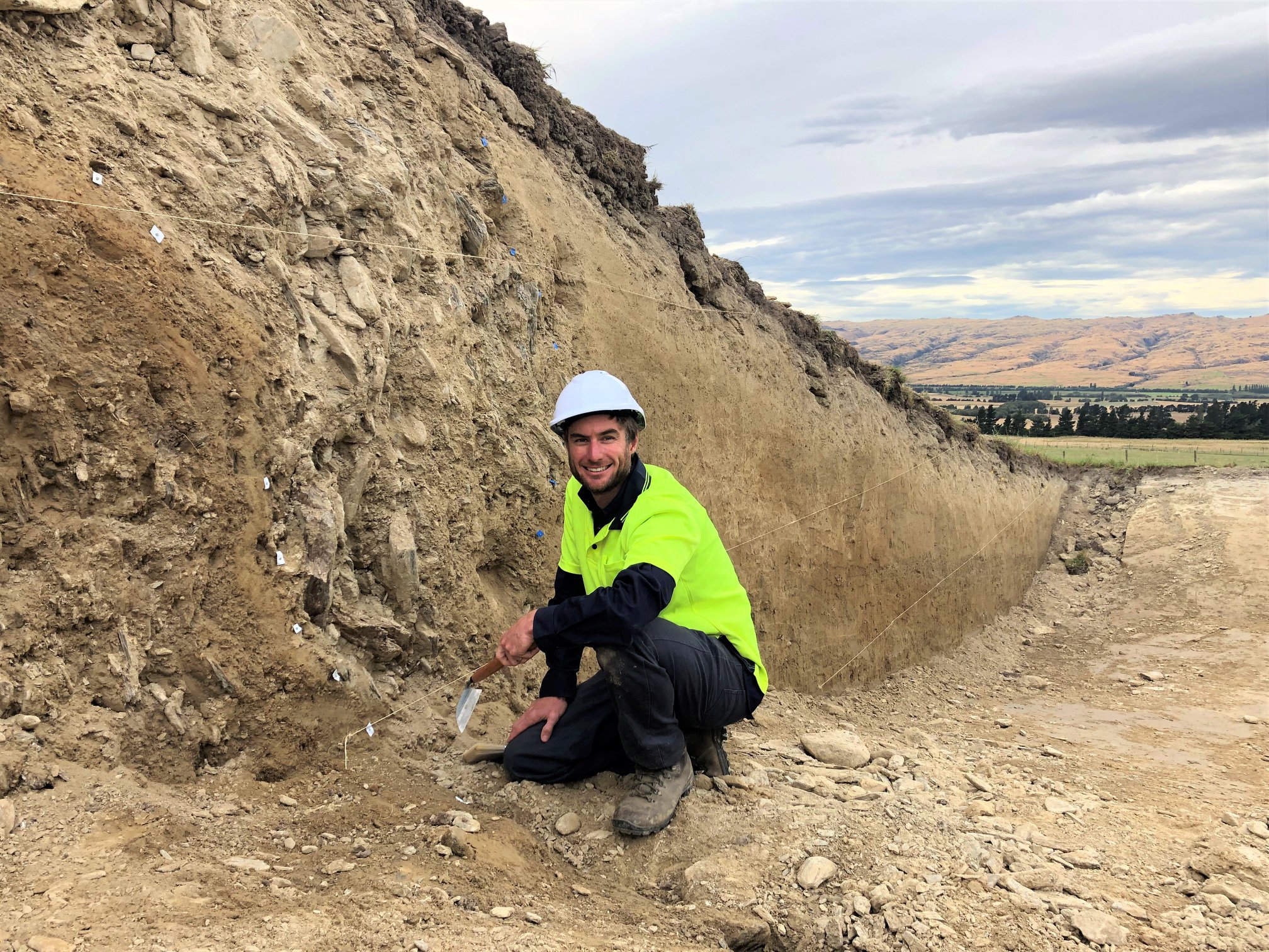
Jono poses on the Hyde Fault. Photo credit: Guy Frederick
Sam Allan
June 2018 – Previous and ongoing projects
Seismic source modelling of low seismicity regions: Otago case study
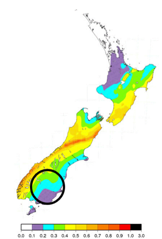
Work is commencing on an EQC-funded project that will seek to tackle the issues of characterising damaging earthquake sources in low-seismicity regions. Our Otago case study (see image below for Otago location in the seismic hazardscape of New Zealand) combines a multidisciplinary team of seismologists (Mark Stirling, Matt Gerstenberger, Erin Todd and Jonathan Griffin), Geodesists (Paul Denys), Mathematicians (Ting Wang), and broad spectrum South Island geologists (David Barrell). Initial efforts are in the compilation of long records of prehistoric earthquakes and cumulative deformation of marker horizons (e.g. Otago peneplain surface), optimising seismicity catalogues to constrain active seismic sources from the distribution of micro-earthquakes, and exploring mathematical and statistical method for combining data sets and quantifying uncertainties. EQC is acknowledged for their support of the project.
Industry work
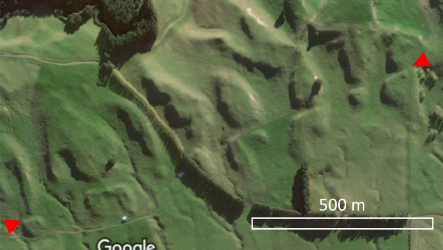
Mark Stirling has continued his role as the lead scientist in a long-standing seismic hazard re-evaluation of the Clyde Dam site in Central Otago. The final report was completed in mid-2018, and stands as a milestone “first” in the use of precariously-balanced rocks to constrain seismic hazard estimates for long return periods. He is also undertaking collaborative work of this nature for the Diablo Canyon nuclear power plant in California, and providing advice on earthquake source characterisation for the Ikata nuclear power plant in Japan. Early in 2018 he also undertook studies of active faults in the vicinity of a proposed wind farm in Hawkes Bay (see image below). Contact Energy Ltd, Pacific Gas and Electric Company, Shikoku Electric Power Company, and Meridian Energy are acknowledged for their support.
Earthquakes, tremor, seamount subduction, and shallow slow slip at the Hikurangi Margin
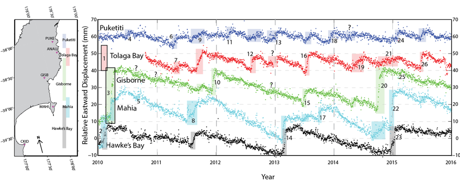
Erin Todd has continued to investigate the occurrence of tectonic tremor and microseismicity associated with shallow slow slip offshore Gisborne along the Hikurangi Margin. Prior to this work, it had been established that Gisborne slow slip events are associated with tectonic tremor downdip of the slow slip patch (Kim et al., 2011, Todd and Schwartz, 2016) and increases in local microseismicity (Delahaye et al., 2009). However, the shallow subduction interface is often poorly resolved due to its distance from land where near source experiments can be conducted. In addition to land-based seismic datasets, Erin has used offshore seismic data from the Hikurangi Ocean Bottom Investigation of Tremor and Slow Slip (HOBITSS) Experiment, which deployed 24 absolute pressure gauges and 15 ocean bottom seismometers to the seafloor above the Gisborne slow slip patch to conduct a detailed investigation into the spatial and temporal extent of slow slip and associated tremor and earthquake activity. This work is done in collaboration with researchers from GNS Science, Victoria University of Wellington, and international researchers from the United States and Japan. The image below of continuous GPS data for 5 stations along the northern Hikurangi shows the frequency and duration of slow slip events (identified by the coloured boxes) along the margin. Most of these slow slip events are accompanied by tectonic tremor and increases in microseismicity. Figure from Todd and Schwartz, 2016.
The close spatial relationship between slow slip, tremor, microseismicity, and subducting seamounts indicates that subducting seamounts may be an important factor in determining the distribution and style of the various styles of interplate slip observed along the northern Hikurangi. Erin is currently collaborating with researchers from GNS Science and NIWA to further investigate the role of seamount subduction in interplate fault slip and impacts to the stress state of the plate interface. The image below shows seamount “knolls” on the incoming plate, which when eventually subducted may greatly impact the style and distribution of interplate slip along the northern Hikurangi Margin.
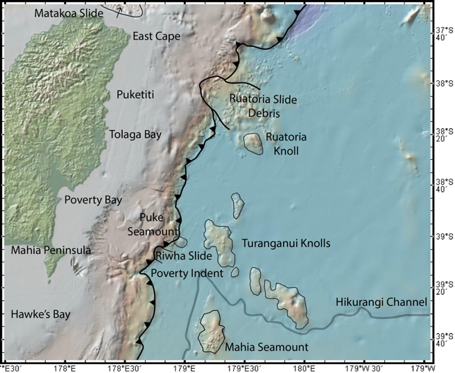
Seamounts on the incoming Pacific Plate that will eventually be subducted beneath the Australian Plate.
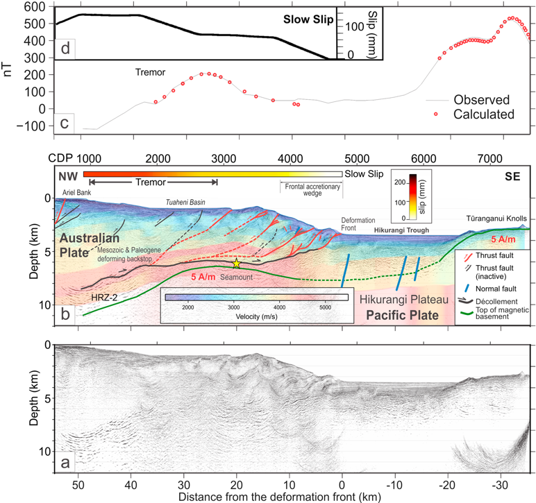
(a) Uninterpreted prestack depth-migrated profile 05CM-04. Vertical exaggeration 2:1. (b) PSDM seismic transect along profile 05CM-04 superimposed on the PSDM P wave velocity model. Thrust faults and splay fault branching are shown in red (active) and black (inactive). The plate boundary décollement is shown in the thick black curve and inter- preted top of the subducting seamount and Tūranganui Knolls is the dark green curve. Yellow star is the epicenter of the 1947 Offshore Poverty Bay earthquake (Bell et al., 2014). Vertical exaggeration 2:1. (c) Observed (solid line) and 3-D calculated magnetic anomalies (red circle) along 05CM-04. (d) Slip (mm) in the September–October 2014 slow slip event on the plate interface along line 05CM-04 is shown by solid line and the color bar in (b). CDP = common depth point reflection; HRZ = high-amplitude reflectivity zone; PSDM = prestack depth migration. (From Barker et al., 2018)
References:
Delahaye, E. J., Townend, J., Reyners, M. E., & Rogers, G. (2009). Microseismicity but no tremor accompanying slow slip in the Hikurangi subduction zone, New Zealand. Earth and Planetary Science Letters, 277(1–2), 21–28. https://doi.org/10.1016/j.epsl.2008.09.038
Kim, M. J., Schwartz, S. Y., & Bannister, S. (2011). Non-volcanic tremor associated with the March 2010 Gisborne slow slip event at the Hikurangi subduction margin, New Zealand. Geophysical Research Letters, 38(14). http://dx.doi.org/10.1029/2011GL048400
Todd, E. K., & Schwartz, S. Y. (2016). Tectonic tremor along the northern Hikurangi Margin, New Zealand, between 2010 and 2015. Journal of Geophysical Research: Solid Earth, 2016JB013480. https://doi.org/10.1002/2016JB013480
Onshore and offshore fieldwork:
A great team of earthquake scientists conducted a 2km long seismic survey of the Dunedin city railway corridor. The purpose of the survey was to provide data to contribute to development of a 3D shear wave velocity model for the city (fieldwork funded by the QuakeCoRE project “A shear wave velocity model for Dunedin” and the NHRP project “Hidden faults under cities”).
MSc student Catherine Sangster operating the seismic recorders during the railway corridor survey
Seismic survey team at the end of the survey. Clockwise from top left: Christopher Seay (volunteer); Andrew Gorman (Geology Department); Catherine Sangster (Geology Department); Franz Lutz (University of Auckland); Hamish Bowman (Geology Department); Mark Stirling (Geology Department); Martin Forbes (Survey School); Erin Todd (Geology Department), and; Patrick Lepine (Inset).
Offshore, Erin Todd took part in the most recent Hikurangi Ocean Bottom Investigation of Tremor and Slow Slip (HOBITSS) scientific cruise where five ocean-bottom absolute pressure gauges that recorded vertical deformation from the 2016 Te Araroa and Kaikoura earthquakes were recovered. Nine new absolute pressure gauges were deployed with an expected recovery in mid-2018.
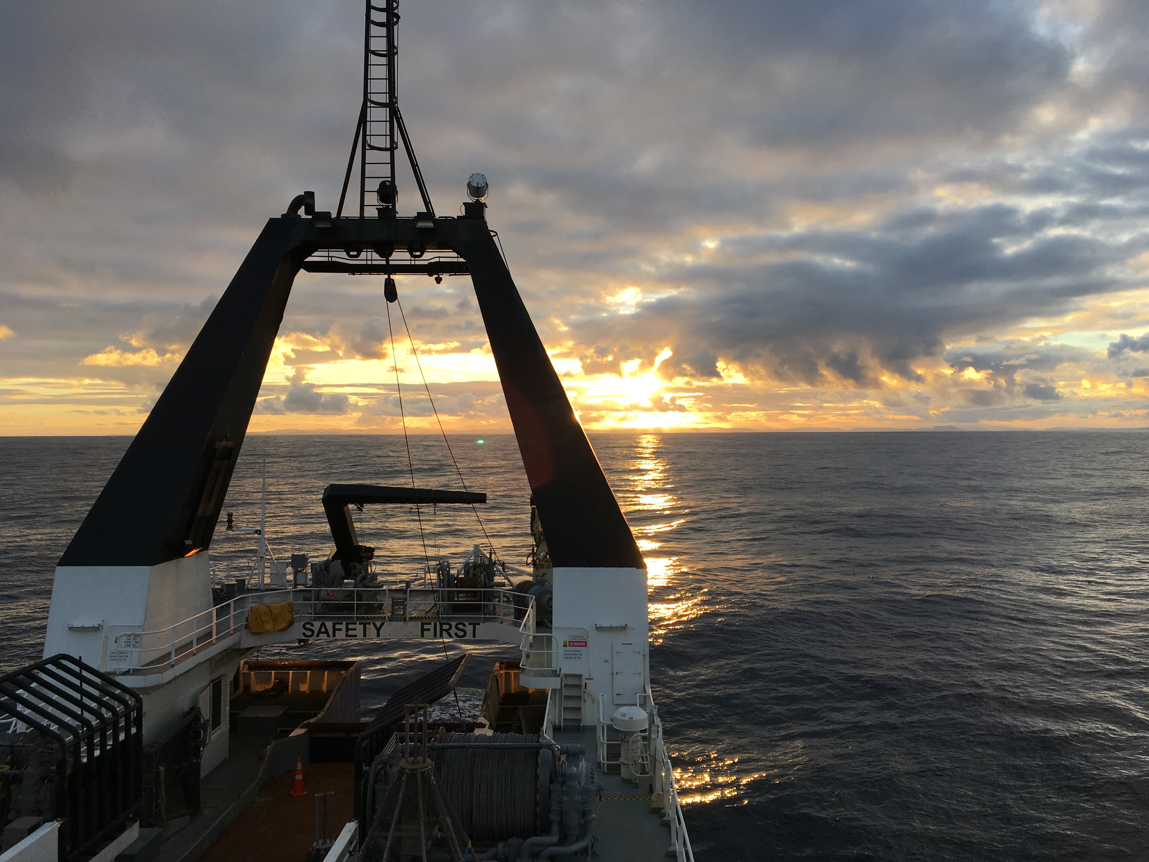
Sunset over the R/V Tangaroa on the HOBITSS(IV) scientific cruise.
Kaikoura Earthquake Work
Mark, together with David Barrell (GNS Science), Jack Williams (Cardiff University), Kat Sauer (University of Otago), and Ella van den Berg (University of Otago) completed the excavation of a paleoseismic trench across the Hundalee Fault, one of the 20+ faults that ruptured in the M7.8 2016 earthquake. The trench has revealed a prehistoric earthquake event that produced >1m fault displacement, which was at least double the 2016 displacement at the site. Current efforts are focused on radiocarbon dating of organic samples taken from the faulted sediments to get some age constraints on the timing of the prehistoric earthquake on the fault. The support of the Natural Hazards Research Platform is acknowledged.
Natural Hazards Research Platform and EQC Proposals
A great team effort went into two funding proposals. The proposal “A multidisciplinary seismotectonic source model for southern New Zealand” went into the Natural Hazard Research Platform contestable funding round, with Ting Wang, Matt Gerstenberger, Erin Todd, Paul Denys, Chris Pearson, Steven Smith, David Barrell and Mark Stirling as the proposal team.
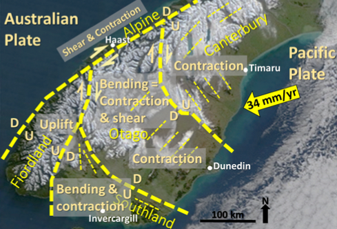
Southern New Zealand, showing major seismotectonic components (outlined by thick yellow dashed lines), with dominant styles of deformation stated. Yellow arrow is Pacific Plate motion relative to fixed Australian Plate. Generalised orientations of faults are shown by thin yellow dashed lines.
Also Andrew Gorman, David Prior, Hamish Bowman, Jennifer Eccles (University of Auckland) and Mark Stirling prepared the proposal “Shear wave velocity model and ground motion simulations for Dunedin city” The proposal has got through the first round of EQC review, so we are now preparing the full proposal.
