Led by Professor Andy Nicol, this pre-workshop field trip will visit some of the surface ruptures and sites of paleoseismicity investigations pertaining to the 2016 Kaikōura earthquake.
What you need to know:
- Date: 12 November (All Day)
- Location: Christchurch – Kaikōura Earthquake surface ruptures – Christchurch
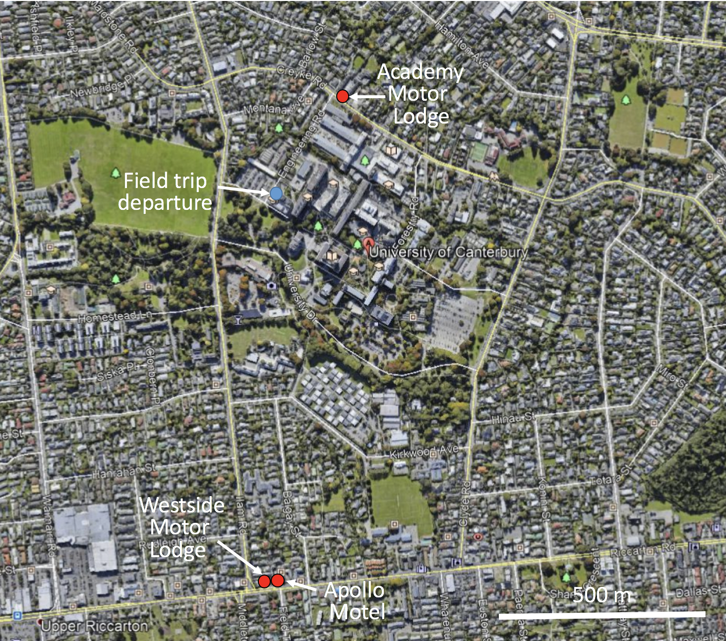
- Accomodation: You will be responsible for finding your own accomodation in Christchurch for the nights of the 11th and 12th. The field trip will start and end from the University of Canterbury, so it is recommended that you find accomodation near the university. Christchurch accomodation can fill up, so it’s best to book this accomodation as soon as possible.
Accomodation near University of Canterbury
- Academy Motor Lodge — Phone: +64 3 351 9347 Fax: +64 3 351 6027 Email: info@academy.co.nz Website: www.academymotorlodge.co.nz
- Westside Motor Lodge — Phone: (+64) 03 341 7254 Fax: (+64) 03 341 7256 Email: reservations@westsidemotorlodge.co.nz Website: http://www.westsidemotorlodge.co.nz
- Apollo Motel — Phone: (+64) 03 348 8786 Email: info@apollomotel.co.nz Website: https://www.apollomotel.co.nz/
- Transportation: Transportation for the field trip will be provided from the Rydges Hotel Latimer Square in the Christchurch CBD at 8:30am and the loading area outside the Ernest Rutherford building at the University of Canterbury at 9:30am.
- Meals: Lunch will be provided, but please bring your own water.
- Cost: No field trip fee, but you will need $5 if you want to taste wines at Waipara Hills Winery.
- Field Trip Sites:
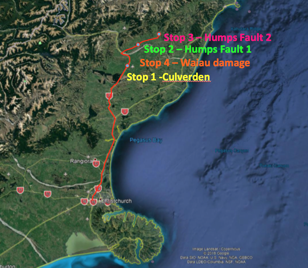
- Culverden
- Humps Fault surface ruptures and trenching site
- Earthquake epicentre in Waiau and damaged church
- Winery stop – Waipara Hills Winery – tasting $5
Depart 8.30-9.00am from Rydges Hotel Latimer Square and the Ernest Rutherford Building at the University of Canterbury by bus.
Stop 1 – Culverden comfort stop and overview of North Canterbury tectonics.
Stop 2 – Introduction to Humps Fault rupture and trenching.
Stop 3 – Waiau – epicentre and damaged church
Stop 4 – Wine Tasting Session at Waipara Hills Winery
Return to University of Canterbury by 7pm.
Detailed Field Trip Guide
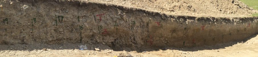
The November 2016 M7.8 Kaikōura Earthquake nucleated on The Humps Fault at a depth of about 14 km, and propagated laterally for ~165 km across the New Zealand plate boundary zone in the northeastern South Island. In the epicentral area the fault ruptured across the Emu Plains, producing a fault scarp <1.5 m in height and up to 3 m of right-lateral displacement on cultural features, including roads and fences. On this field trip we will observe what remains of the 2016 surface ruptures and displacement along The Humps Fault together with damage of buildings in the township of Waiau no more than 5 km from the epicentre. Evidence will be presented for at least four surface-rupturing earthquakes on the fault during the last 16 thousand years. We will discuss why the geometry and paleoearthquake history of the The Humps Fault were poorly constrained prior to the earthquake and what implications this might have for seismic hazard analysis.
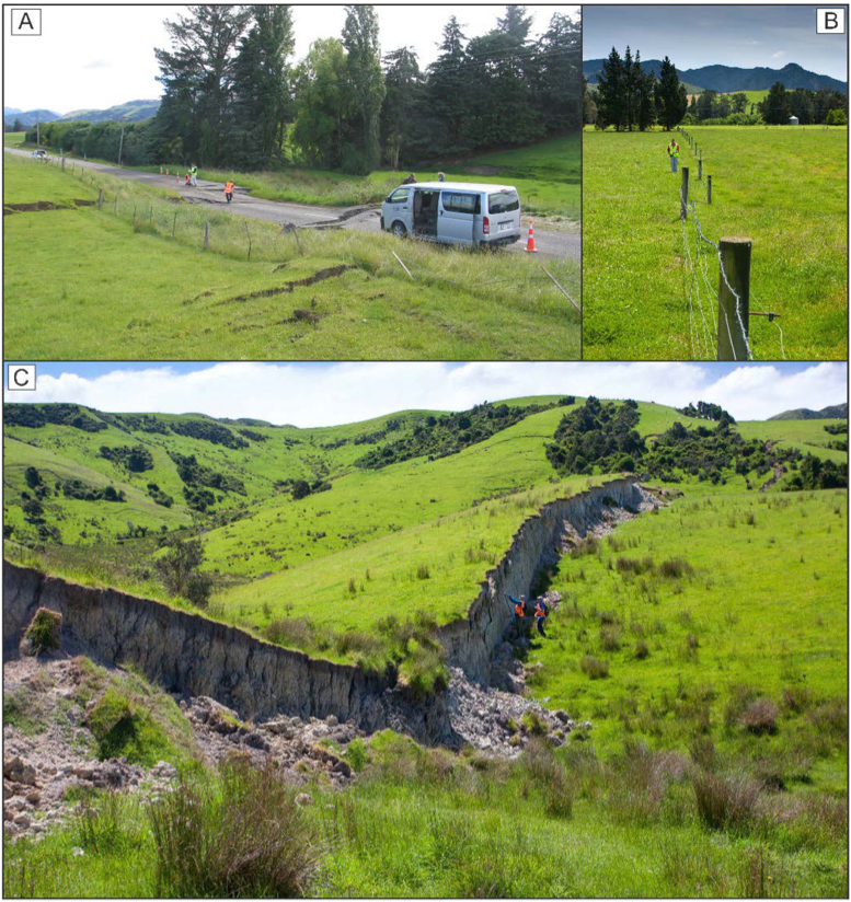
Photographs of Kaikōura Earthquake surface ruptures. (A) The Humps Fault where it crosses the Inland Road (photograph by Jarg Pettinga), (B) Displaced fence line showing ~1.6±0.1m right lateral slip on the The Humps Fault, Emu Plain (photograph by Kate Pedley), (C) “Waiau Wall” locality on the Leader Fault looking northwards ; scarp height is approximately 3.5 m (photograph by Kate Pedley; for further information see Nicol et al, 2018 BSSA 108 (3B), 1521-1539.)
